
« Oblast de Krasnovzaia » : différence entre les versions
Aucun résumé des modifications |
Aucun résumé des modifications |
||
| Ligne 3 : | Ligne 3 : | ||
{| class="wikitable" width="275px" style="float:right;margin:0 0 1em 1em;" | {| class="wikitable" width="275px" style="float:right;margin:0 0 1em 1em;" | ||
! colspan="2" align="center" valign="middle" height="40" style="font-weight: bold; font-size:1,9em; background: #cb0404; color: #ffffff" | Oblast de Krasnovzaia | ! colspan="2" align="center" valign="middle" height="40" style="font-weight: bold; font-size:1,9em; background: #cb0404; color: #ffffff" | Oblast de Krasnovzaia | ||
|- | |- | ||
|+ '''[[Oblast|Oblasts | |+ '''[[Oblast|Oblasts du Thoulak]]''' | ||
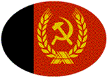
! colspan="2" align="center" | [[Image: | ! colspan="2" align="center" | [[Image:Drapeau046.png|250px]] | ||
|- | |- | ||
| | | Code || align="center" | 04-6 | ||
|- | |- | ||
| | | Capitale || align="center" | [[Krasnostav]] | ||
|- | |||
| Préfet || align="center" | Inconnu | |||
|- | |- | ||
| Population || align="center" | | | Population || align="center" | 162 204. (2016) | ||
|- | |- | ||
| Superficie || align="center" | ??? km² | | Superficie || align="center" | ??? km² | ||
| Ligne 20 : | Ligne 22 : | ||
| Densité || align="center" | ??? hab./km² | | Densité || align="center" | ??? hab./km² | ||
|- | |- | ||
| colspan="2" align="center" |[[Image: | | colspan="2" align="center" |[[Image:06 - Krasnovzaia.png|250px]] | ||
|- | |- | ||
|} | |} | ||
| Ligne 26 : | Ligne 28 : | ||
=[[Fichier:Log Th.gif|45px]] Histoire= | =[[Fichier:Log Th.gif|45px]] Histoire= | ||
=[[Fichier:Log Th.gif|45px]] Géographie= | =[[Fichier:Log Th.gif|45px]] Géographie= | ||
===[[Fichier:Log Th 1.gif|45px]] Population=== | |||
===[[Fichier:Log Th 1.gif|45px]] | |||
===[[Fichier:Log Th 1.gif|45px]] Relief=== | ===[[Fichier:Log Th 1.gif|45px]] Relief=== | ||
===[[Fichier:Log Th 1.gif|45px]] Fleuves Principaux=== | ===[[Fichier:Log Th 1.gif|45px]] Fleuves Principaux=== | ||
= [[Fichier:Log Th.gif|45px]] Divisions administratives= | = [[Fichier:Log Th.gif|45px]] Divisions administratives= | ||
==[[Fichier:Log Th 1.gif|45px]] Communes== | ==[[Fichier:Log Th 1.gif|45px]] Communes== | ||
==[[Fichier:Log Th 1.gif|45px]] | ==[[Fichier:Log Th 1.gif|45px]] Raïons== | ||
=[[Fichier:Log Th.gif|45px]] Infrastructures de transport= | =[[Fichier:Log Th.gif|45px]] Infrastructures de transport= | ||
==[[Fichier:Log Th 1.gif|45px]] Chemin de fer== | ==[[Fichier:Log Th 1.gif|45px]] Chemin de fer== | ||
==[[Fichier:Log Th 1.gif|45px]] Le Réseau Routier == | ==[[Fichier:Log Th 1.gif|45px]] Le Réseau Routier == | ||
==[[Fichier:Log Th 1.gif|45px]] Le Réseau de Bus == | ==[[Fichier:Log Th 1.gif|45px]] Le Réseau de Bus == | ||
==[[Fichier:Log Th 1.gif|45px]] Aéroport == | ==[[Fichier:Log Th 1.gif|45px]] Aéroport == | ||
=[[Fichier:Log Th.gif|45px]] Galerie d'Images= | =[[Fichier:Log Th.gif|45px]] Galerie d'Images= | ||
{{Modèle:Oblast TH}} | {{Modèle:Oblast TH}} | ||
Version du 11 octobre 2016 à 18:52

| Oblast de Krasnovzaia | |
|---|---|

| |
| Code | 04-6 |
| Capitale | Krasnostav |
| Préfet | Inconnu |
| Population | 162 204. (2016) |
| Superficie | ??? km² |
| Densité | ??? hab./km² |

| |
 Histoire
Géographie
 Population
Relief
Fleuves Principaux
Divisions administratives
Communes
Raïons
Infrastructures de transport
Chemin de fer
Le Réseau Routier
Le Réseau de Bus
Aéroport
Galerie d'Images
| Oblast de la RST | |
|---|---|
| Oblast de Maslograd (Capitale Maslograd) ••• Oblast de Khrystofski (Capitale Khrystofgrad)••• Oblast de Yarkiyne (Capitale Yarkyine)••• Oblast de Novaya Tulsk (Capitale Novaya Tulsk)••• Oblast de Chtchoïa (Capitale Chtchoïa)••• Oblast de Krasnovzaia (Capitale Krasnostav) ••• Oblast de Sazash (Capitale Iekaterin) |